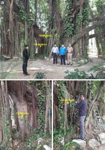
Bhubaneswar: Odisha officials claimed on Friday that the state has re-established itself as one of the country’s most successful models in mangrove conservation, delivering significantly improved ecological, economic, and climatic outcomes.
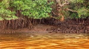
With their intricate root systems, mangrove forests stabilize coastlines, thereby mitigating erosion caused by storm surges, currents, waves, and tides.
Mangrove forests are regarded as natural barriers against tidal surges and cyclones. Thanks to their dense mangrove cover, cyclonic storms frequently fail to penetrate these wetland regions.
Odisha possesses a reserved mangrove forest area spanning 259.06 square kilometers, the majority of which is situated in Bhitarkanika. This places the state in the second position nationally, following West Bengal’s Sundarbans. In addition to Bhitarkanika in Kendrapara district, mangrove forests—also recognized as coastal forestlands—are found in the districts of Balasore, Bhadrak, Jagatsinghpur, and Puri.
Located in Kendrapara district, the Bhitarkanika National Park alone extends over an area exceeding 212 square kilometers, making it one of India’s most critical mangrove ecosystems.
Odisha’s mangrove forests are not merely woodlands; they serve as a vital bio-shield against cyclones and storm surges—a crucial function given that the state is frequently impacted by extreme weather events. Their dense root systems absorb wave energy, reduce coastal erosion, and stabilize coastlines.
Furthermore, they contribute to carbon sequestration, support biodiversity, and bolster fisheries, thereby enhancing coastal livelihoods and food security. According to ISFR data, the mangrove cover in Odisha has increased by 16.6 percent over the past decade, rising from 222 square kilometers in 2011 to over 259.06 square kilometers in 2023. This progress positions Odisha as a national leader in the fields of combating climate change, ecological governance, and nature-based coastal resilience.